We’ve added a duplex LCD to our digital model with direct function buttons for one-push measurements. The rotating bezel, case, case back, and urethane band are made with plant-derived, renewable biomass plastics. Introducing this PRO TREK and celebrating its trailblazing progress in every direction: easy to use, easy to read, easy on the environment.


The dual-layer LCD allows compass graphics to be shown on the top layer, while the bottom layer offers a large display of the time and various measurements. We’ve also made the LCD slimmer to minimize bulk, even with the dual-layer construction.

The case, case back, and soft urethane band are all made with the Earth-friendly green material known as bio-mass plastics. Using renewable organic resources such as castor oil plants and corn helps reduce the ecological footprint. Eco-consciousness rendered in physical form, a fitting material for a real outdoor tool.
*Bio-mass plastics are not used in the metal band of the PRG340T.

Measure direction, air pressure and temperature, and altitude, each one available directly from a single button. The oversized buttons feature a nonslip finish for effortless use even when wearing gloves. In addition, improved sensor placement makes the side of the case even slimmer. The buttons are easier to press now, too.
The bezel incorporates a rotating mechanism, allowing it to be used for simple orientation memory. The movable lug structure enables the watch case and band to be laid flat — handy when working with paper maps, checking where you are and where you’re going.

The Triple Sensor (digital compass, barometer/altimeter, and thermometer) senses natural changes

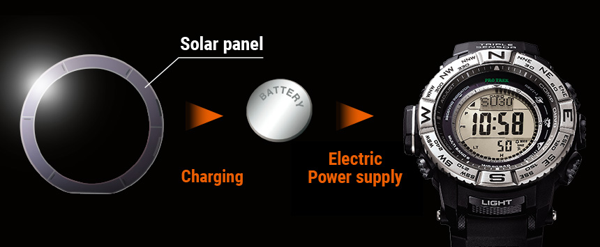
Tough Solar powered for converting light to energy

Super Illuminator (high-brightness full-auto LED backlight) for maintaining watch readability in the dark
*Image shows the PRG340-1.


This proprietary CASIO solar-powered battery-recharging system assures stable operation of various power-hungry functions, including dial lighting, alarms, stopwatches and measurement functions.


Measuring altitudes based on changes in atmospheric pressure
The altimeter determines the altitude at your current location based on accumulated atmospheric pressure changes measured by the pressure sensor. Setting the altimeter at a location where you know the precise altitude before starting your ascent enables it to take even more precise altitude measurements.
Sea level measurement
Setting the altimeter at a location where you know the precise altitude enables you to determine the elevation of your current position with respect to sea level. If you come across a marker indicating 400 meters above sea level while hiking or climbing, for example, simply set the altimeter at 400 meters. This enables you to obtain more accurate readings with respect to sea level when you take subsequent measurements after moving on.
Altitude memory
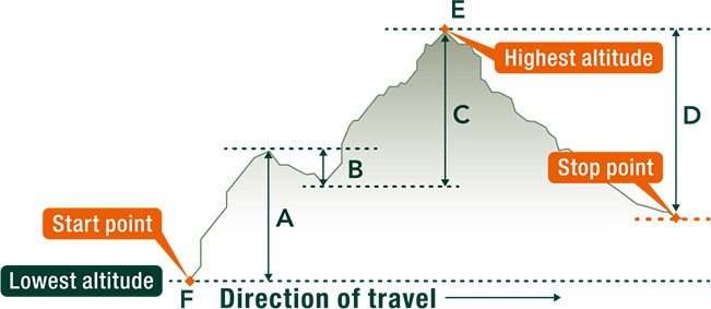
The altitude memory stores data on the month, date, time and results of altitude readings taken automatically at regular intervals and displays the highest and lowest altitudes measured as well as the cumulative ascent/descent altitude and relative altitude. This data provides an easily understandable summation of your ascents and descents during a climb.

- Cumulative ascent altitude : total of ascent altitudes (A + C)
- Cumulative descent altitude : total of descent altitudes (B + D)
- Highest altitude : altitude measured at the highest point E among all readings during memory measurement
- Lowest altitude : altitude measured at the lowest point F among all readings during memory measurement
- Highest/lowest previous record altitudes
- Sum of cumulative ascent/descent altitudes : computed repeatedly at time of memory measurements between 0 and 99,995 meters
Altitude differential display
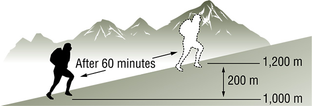
Checking against contour lines on a map enables you to confirm your cumulative ascents/descents. Determining the height of your hourly ascents by resetting the altitude differential display once an hour can be helpful in establishing a reasonable climbing plan, for example.

*These measurement functions are not intended for use as professional instruments. Please use the measured data for reference purposes only.

Forecasting the weather based on the atmospheric pressure tendency
A graphic display of atmospheric pressure readings taken at regular intervals reveals pressure trends at a glance. When the pressure is rising, the weather is likely to improve; when it’s falling, there’s usually worse weather ahead. This feature can remind you to take your swimming suit along, or alert you to approaching trouble.

Atmospheric pressure tendency graph / Atmospheric pressure tendency indicator
The barometer measures the atmospheric pressure every two hours automatically and displays the recent atmospheric pressure tendency and the current pressure graphically.


Aligning a map with the surrounding terrain
If you determine magnetic north with the direction measurement function and place a map beside your watch, you can align the map with the surrounding geography.
Magnetic declination correction
You can change the direction measurement standard from “magnetic north” to “true north” by inputting the magnetic declination data indicated on a topographical map to correct the direction.

Bearing Memory [selected models only]
The Bearing Memory memorizes directions detected by the direction measurement function and displays them continuously in graphic format. You can travel straight toward your destination by following a course determined with the memorized direction displayed steadily in the 12 o’clock position on your watch face. This capability also comes in handy when visibility is low due to such factors as trees or fog.


Predicting your destination temperature based on the temperature at your current location
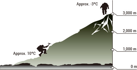
The temperature generally decreases by approximately 6.5°C with every increase in altitude of 1,000 meters, or 3.6°F with every increase of 1,000 feet. If the temperature at 1,000 meters is 10°C, therefore, the temperature at 3,000 meters will probably be about -3°C.


Using Sunset, Sunrise time data to plan climbs
Knowing the time remaining before sunset helps you to schedule climbs to assure a safe descent, for example, or to determine the appropriate time to wake up or pitch a tent.
Fishing during sunrise and sunset hours when the fish are biting
Checking the sunrise and sunset times in advance gives you a good idea of when you can expect the best fishing, so you can make your fishing plans accordingly.

- Case / bezel material: Bio-Based Plastic Resin
- Bio-Based Plastic Resin Band
- Mineral Glass
- Direction Bezel
- 100-meter water resistance
- Electro-luminescent backlight
Full auto EL light, selectable illumination duration, afterglow - Tough Solar (Solar powered)
- Low-temperature resistant (-10 °C/14 °F)
- Digital compass
Measures and displays direction as one of 16 points
Measuring range: 0° to 359°
Measuring unit: 1°
20 seconds continuous measurement
Graphic direction pointer
Bidirectional calibration and northerly calibration function
Magnetic declination correction
Bearing memory - Altimeter
Measuring range: -700 to 10,000 m (-2,300 to 32,800 ft.)
Measuring unit: 5 m (20 ft.)
Manual memory measurements
(up to 25 records, each including altitude, date, time)
High Altitude / Low Altitude memory
Total Ascent / Descent memory
Others: Reference altitude setting, Altitude tendency graph, Altitude differential
*Changeover between meters (m) and feet (ft) - Barometer
Display range: 260 to 1,100 hPa (7.65 to 32.45 inHg)
Display unit: 1 hPa (0.05 inHg)
Atmospheric pressure tendency graph
Atmospheric pressure differential graphic
*Changeover between hPa and inHg - Thermometer
Display range: -10 to 60 °C (14 to 140 °F)
Display unit: 0.1 °C (0.2 °F)
*Changeover between Celsius (°C) and Fahrenheit (°F) - Duplex LC display
- World time
31 time zones (48 cities), city code display, daylight saving on/off - Sunrise, sunset time display
Sunrise time and sunset time for specific date, Daylight pointers - 1/100-second stopwatch
Measuring capacity: 23:59’59.99”
Measuring modes: Elapsed time, split time, 1st-2nd place times - Countdown timer
Measuring unit: 1 second
Countdown start time setting range: 24 hours
Countdown start time setting range: 1 minute to 24 hours (1- minute increments and 1-hour increments) - 5 daily alarms
- Hourly time signal
- Battery level indicator
- Power Saving (display goes blank to save power when the watch is left in the dark)
- Full auto-calendar (to year 2099)
- 12/24-hour format
- Button operation tone on/off
- Regular timekeeping:
Hour, minute, second, pm, year, month, date, day - Accuracy: ±15 seconds per month
- battery operating time:
6 months on rechargeable battery (operation period with normal use without exposure to light after charge)
23 months on rechargeable battery (operation period when stored in total darkness with the power save function on after full charge) - Size of case: 54.7×51.7×15.1mm
- Total weight: 54g
- Module: 3513
- UPC: 889232328058


